At approximately 05:45 on July 8, 2025, a glacial lake outburst event occurred in Sale Township, Gyirong County, Shigatse City, Tibet, causing the water level of the Donglin Zangbo River to rise rapidly (Figure 1).
This sudden flood left 11 people missing on the Chinese side, and 6 Chinese personnel were also reported missing on the Nepalese side. Under the powerful impact of the flood, the "Friendship Bridge" at the China-Nepal border located at the Gyirong Port was destroyed, and multiple electric vehicles and containers were swept into the river.
▲Figure 1 Glacial lake outburst event in the Donglin Zangbo basin
PART 02 Glacial lake outburst triggering flash floods/debris flows
State Key Laboratory of Geohazard Prevention and Geoenvironment Protection, Chengdu University of TechnologyBased on the previously constructed Tibetan Plateau glacial lake database (Dou et al., 2023) and the glacial lake susceptibility assessment results from existing studies,a total of 55 glacial lakes are distributed in the upstream basin of the "Friendship Bridge," with a total area of approximately 3.39 km². Based on Sentinel-2 remote sensing imagery from July 8, a verification of the geomorphological-vegetation change characteristics of all tributary gullies upstream of the Friendship Bridge found thatthis event was caused by the outburst of a supraglacial lake on the glacier upstream of the Purepu Zangbo (Figure 2).
▲Figure 2 Area changes before and after the outburst of the supraglacial lake on the glacier upstream of the Purepu Zangbo
Prior to the outburst event, the glacial lake was continuously expanding, from 0.28 km² on June 10, 2025, to 0.60 km² on July 5. After the outburst on July 8, the glacial lake still had 0.46 km², a decrease of 0.14 km². Using the Sentinel-1satellite imageryobtained via ESA (July 9, 2025), water bodies were identified using polarization enhancement combined with the Otsu method, and areas with geometric distortion were masked, yielding a water body area of 0.18 km² on July 9—a decrease of 0.42 km² compared with before the outburst and 0.28 km² compared with after the July 8 outburst. This indicates that after the rapid outburst on July 8, the glacial lake transitioned to a slow drainage process, which also explains why the Donglin Zangbo River remains in a flood state.

▲Figure 3 Area changes before and after the glacial lake outburst (top: optical imagery; bottom: SAR imagery)
The outburst flood caused obvious changes in the downstream channel, with some sections significantly widened (Figure 4). Remote sensing imagery shows that the outburst flood advanced downstream along the glacier surface, and multiple bead-like small lakes still remain on the glacier surface.
▲Figure 4 Geomorphological changes of the channel at the glacier tongue front before and after the glacial lake outburst
PART 03 Historical outburst events of the glacial lake
Remote sensing imagery indicates that this was not the first outburst of this glacial lake. As early as mid-July 2023, an outburst event occurred at this glacial lake, and the lake area decreased significantly. The outburst flood caused substantial widening of the channel (Figure 6). Before the outburst, the glacial lake area was 0.45 km²; after the outburst, 0.23 km² remained, a decrease of 0.22 km².
▲Figure 5 Characteristics before and after the 2023 glacial lake outburst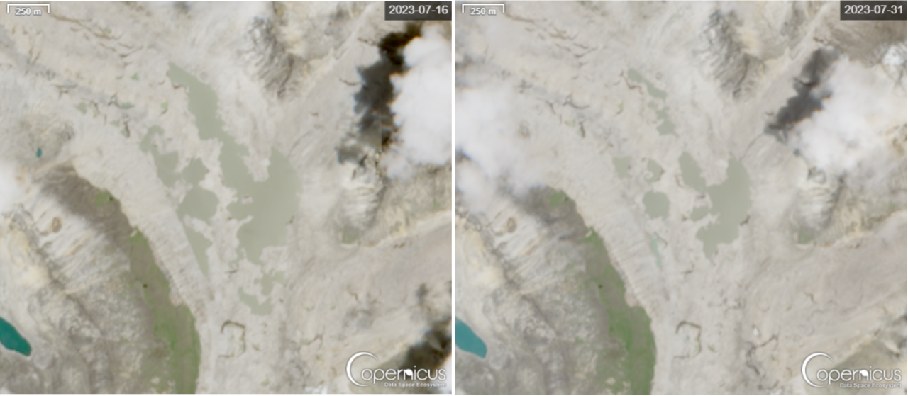
▲Figure 6 Geomorphological change characteristics of the channel at the glacier tongue front before and after the 2023 glacial lake outburst
▲Figure 7 Area changes before and after the 2023 glacial lake outburst
PART 04 Development history of the glacial lake
Interpretation of historical remote sensing imagery (Figures 8–10) shows that this glacial lake is a typical supraglacial lake that began forming in 2018. Under the influence of climate warming, multiple supraglacial lakes on the glacier surface have shown an expanding trend and gradually become interconnected, causing the overall scale of the glacial lake to continuously increase. By the time of the outburst on July 8, 2025, the glacial lake had developed to its largest area on record. It should be noted that this glacial lake does not exist year-round but exhibits significant seasonal characteristics. Each year from April to May, as temperatures rise and precipitation increases, the glacial lake water level continues to rise, as in June 2019 (Figure 8, left), June 2020 (Figure 9, left), and May 2021 (Figure 10, left). By June–July, the subglacial drainage channels gradually become connected, the water level drops significantly, and the glacial lake recedes, with only scattered small supraglacial lakes remaining on the glacier surface (Figures 8–10, right). This process is consistent with the glacier hydrological characteristics of this region, which lies in the transition zone betweencontinental-type glaciersand maritime-type glaciers on the Tibetan Plateau. Precisely because of its seasonal variation characteristics, several glacial lake databases have not yet included this glacial lake in their records.
▲Figure 8 Area changes caused by glacial lake drainage in 2019
▲Figure 9 Area changes caused by glacial lake drainage in 2020
▲Figure 10 Area changes caused by glacial lake drainage in 2022
PART 05 Glacial lake outburst mechanisms and influencing factors
Meteorological monitoring data show thatover the past five years, this region has experienced a significant warming process, with a magnitude far exceeding the average warming level of the Tibetan Plateau, thereby driving the continuous expansion of the glacial lake area. In 2024, the temperature increase was particularly pronounced, and the supraglacial lake expanded rapidly, providing a favorable disaster-pregnant environment for this glacial lake outburst event. Theoretically, rising temperatures facilitate the connection and drainage of subglacial seepage channels, but the actual situation is more complex. The intense meltwater runoff brought by warming, while accelerating glacier ablation, may also carry large amounts of moraine material, which instead blocks the subglacial drainage channels. It is speculated that this blocking effect impeded the effective discharge of glacial lake water, causing the lake water level to exceed historical extremes and ultimately triggering the outburst event. Remote sensing imagery shows thatthe outburst flood advanced downstream along the glacier surface toward the channel, with no obvious changes at the breach; therefore, piping failure is inferred. However, because the breach of such supraglacial lakes is relatively narrow, low-resolution imagery cannot accurately determine it, and more monitoring data and remote sensing imagery are still needed. As in the 2023 and 2025 events, such sudden piping processes can rapidly release the glacial lake, triggering downstream floods or geological hazards such as debris flows. In other respects, meteorological data indicate that no rainfall occurred in the town area at the time of the glacial lake outburst (no rainfall data are currently available at high altitudes), so the probability that this event was caused by heavy rainfall is inferred to be low. Meanwhile, remote sensing imagery shows no obvious signs of ice/rock avalanches entering the lake, so the probability of an ice avalanche–surge–outburst flood is also low. Based on available data, it is inferred that the glacial lake most likely failed by piping. After the "7.8" event in 2025, the glacial lake area decreased by 0.13 km², less than the 0.22 km² in 2023. Based on the empirical glacial lake area–volume formula, it is preliminarily estimated that the 2025 glacial lake released 62,000 m³ of water, and the 2023 event released 120,000 m³. However, the 2025 event caused more severe damage. Due to the lack of field measurement data and remote sensing imagery, the main reasons are inferred to be: 1) The piping failure in the 2025 event was faster, generating a larger peak discharge, whereas the 2023 failure was slow; despite the larger volume, the peak discharge was lower; 2) During the flood propagation in the 2025 event, the along-channel erosion amplification effect was more significant.
PART 06 Recommendations
At present, there are still many glacial lakes in this basin, and attention should be paid to the possibility of another glacial lake outburst flood. Early warning of upstream floods should be strengthened to ensure that downstream emergency rescue and disaster relief proceed smoothly and in an orderly manner. Furthermore, strong earthquakes and extreme climate conditions should be fully considered, and more detailed susceptibility and risk assessments should be carried out for all glacial lakes in this basin as soon as possible, to serve post-disaster reconstruction and long-term stability.
Emergency Rescue and Disaster Relief | Battling Floods to Keep Roads Open and Safe, Pooling Strength for Emergency Repairs and Safe Travel
下一篇Yuchai Showcases at the 2025 Japan Industrial Exhibition

2026-10-14 0 0
2026-09-28 36 0
2026-09-22 10749 0

2026-09-18 11026 0

Lize City Air Terminal Underground Main Structure Nearing Completion: Maximum Transfer Walk Under 4 Minutes After Operation

Anti-seepage Curtain for Main Lock Pit of CSCEC Port Shenqiu Double-Line Lock Project Completed on Schedule

All Pile Foundations Completed on Quanzhou Baiqi Channel
Hainan Upgrades Housing and Municipal Infrastructure

First Foundation Concrete Pour Successfully Completed for Zambia Kafue West–Muzuma 330kV Transmission Line EPC Project
Hot News

评论 (0)